


There's Curry And Dams In Them Thar Hills
There's Curry And Dams In Them Thar Hills
A 65km round trip ride to a new curry restaurant in Yasaka (inland Hamada) from Misumi returning via the Onagami dam

The Misumi/Yasaka area of Hamada and the adjacent Mito part of Masuda are places where I’ve done a lot of cycling. It’s a very scenic area with some fairly good roads - including a spot on the Masuda side which was the Japan National Cycle Championship Course a couple of years ago (that’s a 14.2km circuit, the competitors did multiple laps of it).
There are a couple of possible start points in Misumi, generally I recommend the Misumi Central Park (三隅中央公園) as it has public toilets, vending machines and plenty of places to park. Hence that is the start for this ride. It also has the Sekishu Art Museum and Sekishu Washi (paper) craft atelier (石州和紙会館) if you want to be touristy.
If you don’t want to start there then Misumi Park/Misumi Jinja (三隅公園/三隅神社) is an alternative - in the spring it is well worth visiting the shrine and park even if you don’t start there, the plum blossom, then cherry blosson then later the tsutsuji make it a very pretty place. Both are easy to reach from route 9 and the Misumi exit of the Sanindo highway.
The ride described here starts at Misumi Central Park and is about 65km with about 1000m of elevation gain/loss mostly in two major climbs
Start down the hill by the museum, turn right at the bottom and then follow the river bank around then head down to the right and pass under route 9 and cross over the river. On the far side of the bridge turn right and continue on the river bank until you get to another bridge. Turn right onto the bridge and left when you’ve crossed over either immediately at the end of the bridge or at the traffic light just afterwards (kendo 県道48) so that you are now heading back up river again. Which ever turn you took relax, they merge around a bend or two and you need to just keep on going up the river.
Congratulations, you can now relax. You have handled the most complicated bit of navigation on the course and the bit with the most traffic. From now on you can enjoy the countryside. Also now would be a really good moment to confirm that you filled your water bottle because the vending machines you see in the next kilometer or two will be the last you see until you get all the way up the hill to Yasaka.
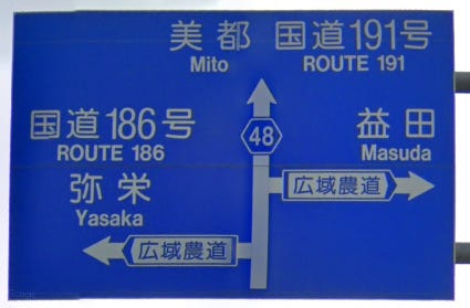
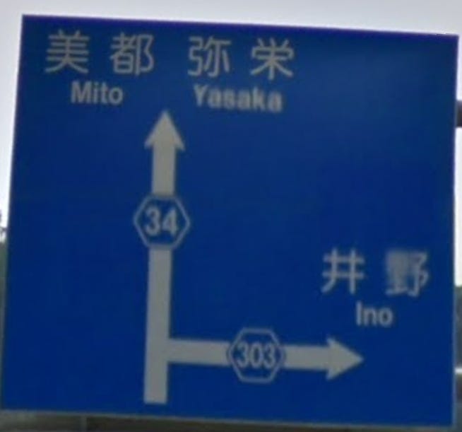
After about 6.5 km you’ll see a sign for Yasaka and Route 186 to the left. Take that road, which crosses over the river again, and then shortly afterwards enters a 1.2km long tunnel. You will stay on this road as it climbs (with a couple of intermediate descents) all the way up to Yasaka.
[Alternative if you want - you can continue straight on in the direction of Mito. Then when you get to where Kendo 48 turns right continue straight on following signs to Onbe Dam (kendo 県道179). Go past Kowa Onsen (which is BTW a good alternative start for this as you can have a bath when you’re done) and up to the dam. Continue on the left hand side of the lake and when you get to a cross roads where 179 turns left continue straight (unless you like really poky roads :) ) and you’ll merge back into the main route just before the last climb up to Yasaka ]
Once you descend into Yasaka passing the Junior High School on the right (~17.5km from the start) turn left onto a small road immediately after you cross a bridge and before the roadsign about a junction with kendo 県道34. In a couple of hundred meters you’ll get to a junction with another road crossing back over the river. Cross over the river and turn right again to take the road that runs by the side of the river. The road stays by the river for about a kilometer or so before gradually diverging and climbing up to a small pass. Once you reach the top of the pass and start descending look a junction with a couple of other roads as the trees thin out (~21.5km from start). This is where you will find the curry restaurant for lunch (山のカレー屋 トラトラ). You should probably click on that link to check when it is open as well as finding the phone number or online reservation page and making a reservation.
[An alternative that may be useful if you are out of drink is to continue to kendo 県道34 and turn left up it. You’ll find a drink machine on the right up the little road at the crossroads after the post office. After you’ve got your drinks continue back up kendo 県道34 as it winds up the valley. Just before it enters a tunnel turn left and after a hundred meters or so you’ll come to the same junction mentioned above. You should be able to see the flags flapping in front of the restaurant as you climb up the last bit of climb on the kendo]
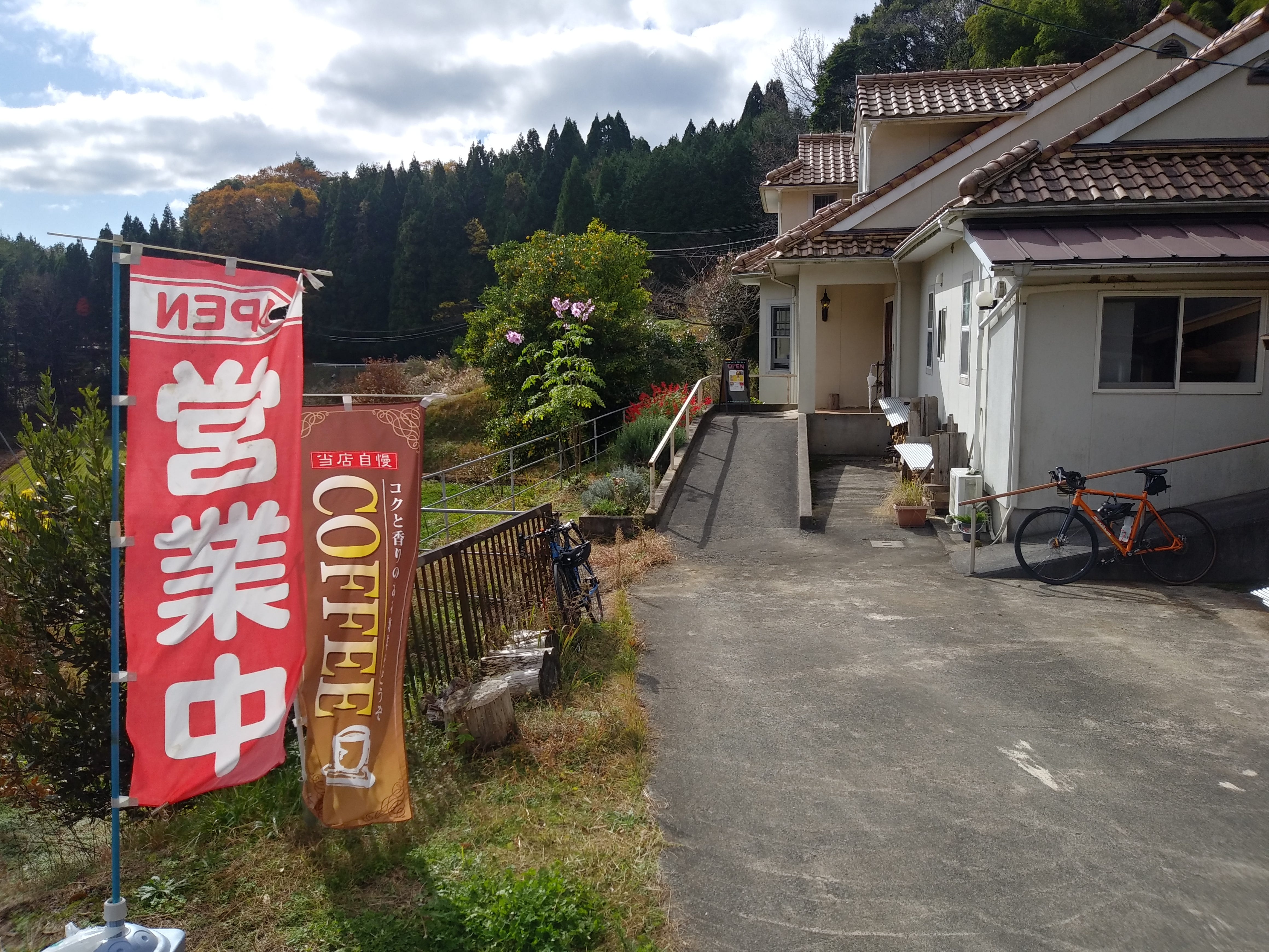
Note that to get to the restaurant you need to go down the second really narrow road to the right not the wider first road which takes around the back of the restaurant but doesn’t let you get in to it.
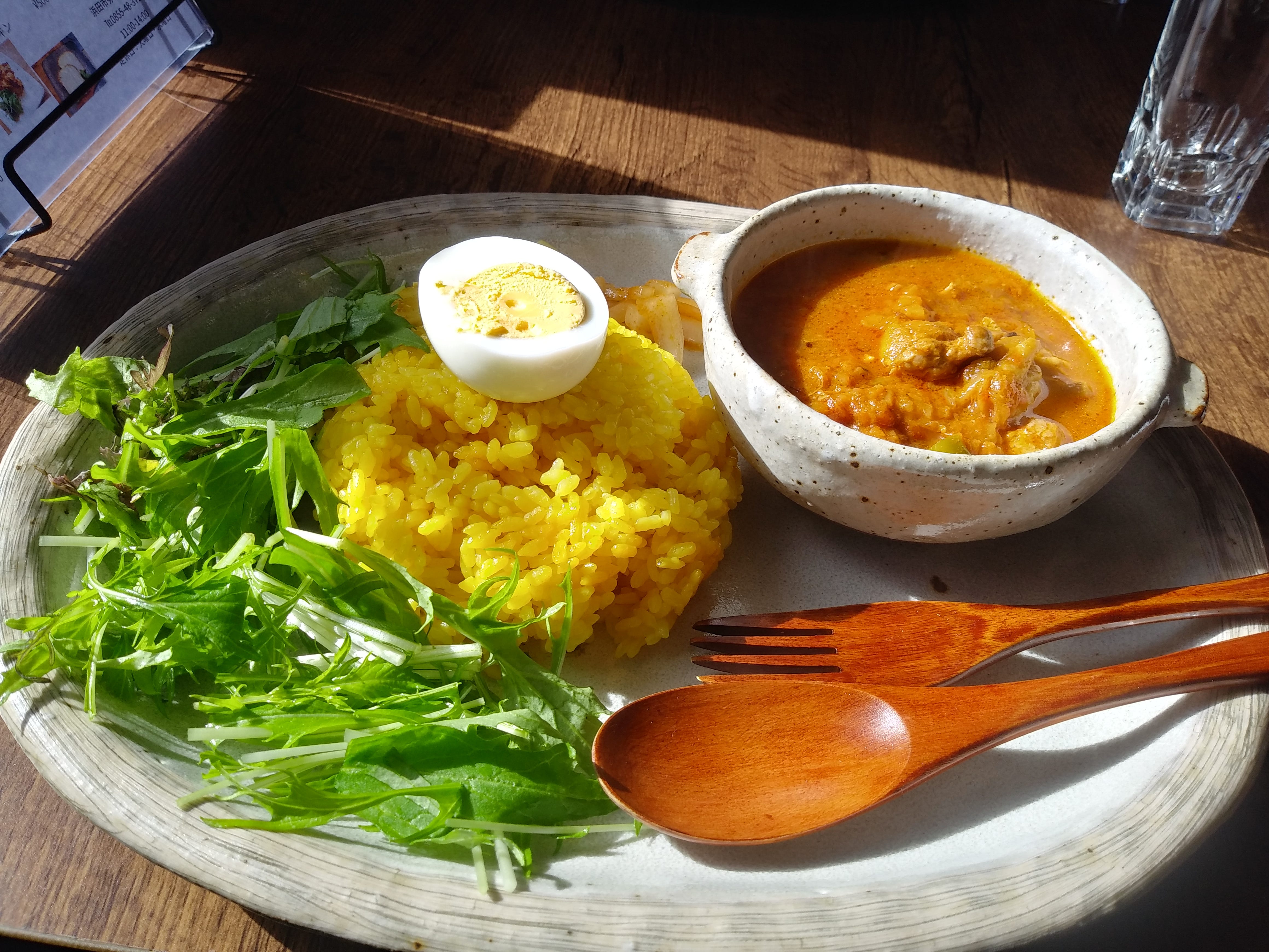
The menu isn’t extensive and is all curry (and very good curry at that, with use of freshly ground and mixed spices). If curry doesn’t appeal then there are a couple of other restaurants in the area. The only one I’ve been to is the udon one (陽気な狩人) which is a little further along the route.
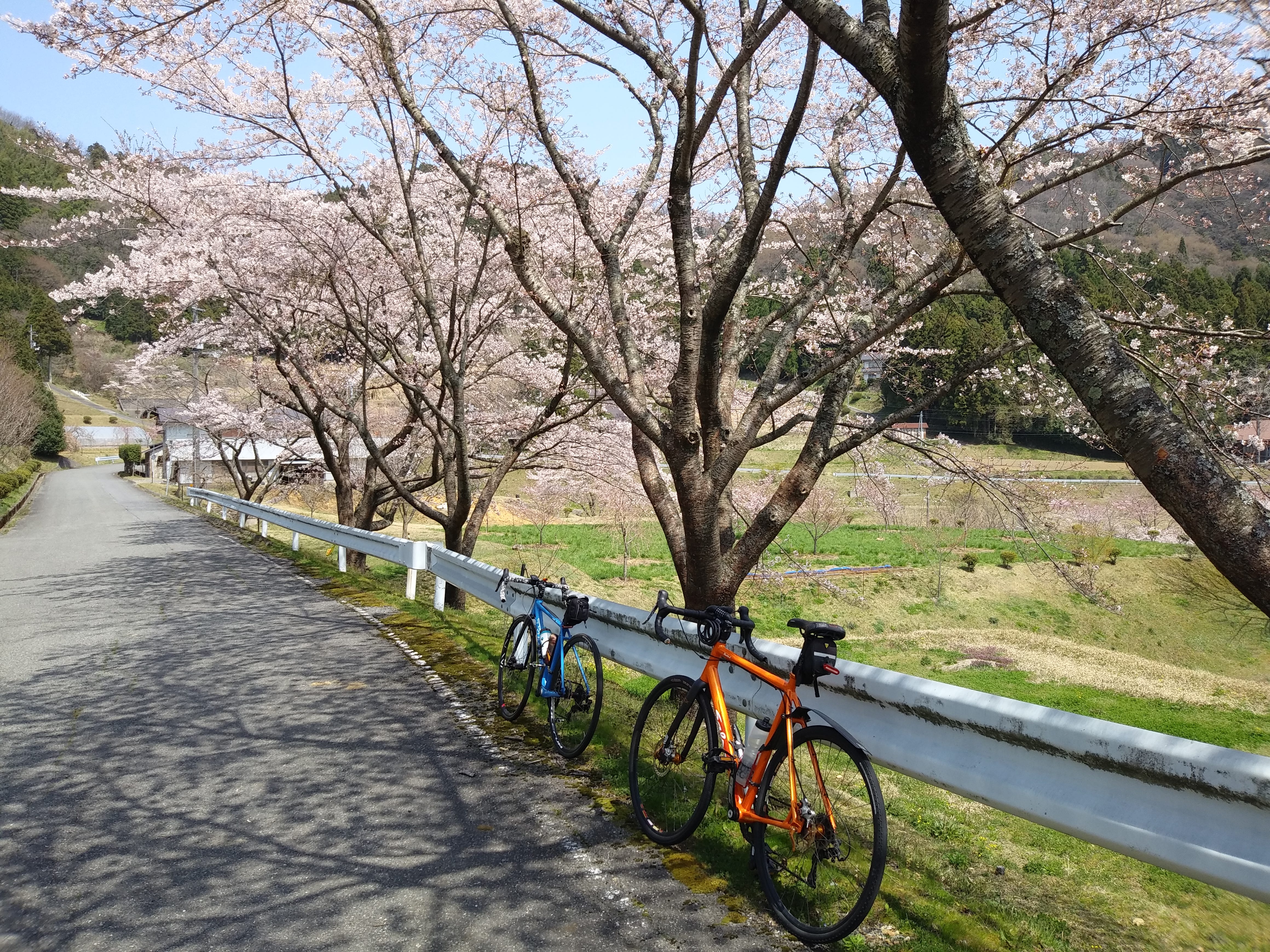
If you do this ride in spring there are some magnificent cherry trees just by the road junction and continuing along the road to the main road (kendo 県道34). Admire them if you can. Either way after lunch continue on the road until you get to the main road,. Turn right and head downhill.
[Shortcut alternative: turning left on kendo 県道34 gets you to a tunnel, if you go through that and then continue down the hill, eventually - after a second tunnel, you’ll see the turn to kendo 県道303 which the main route comes up to after the dams]
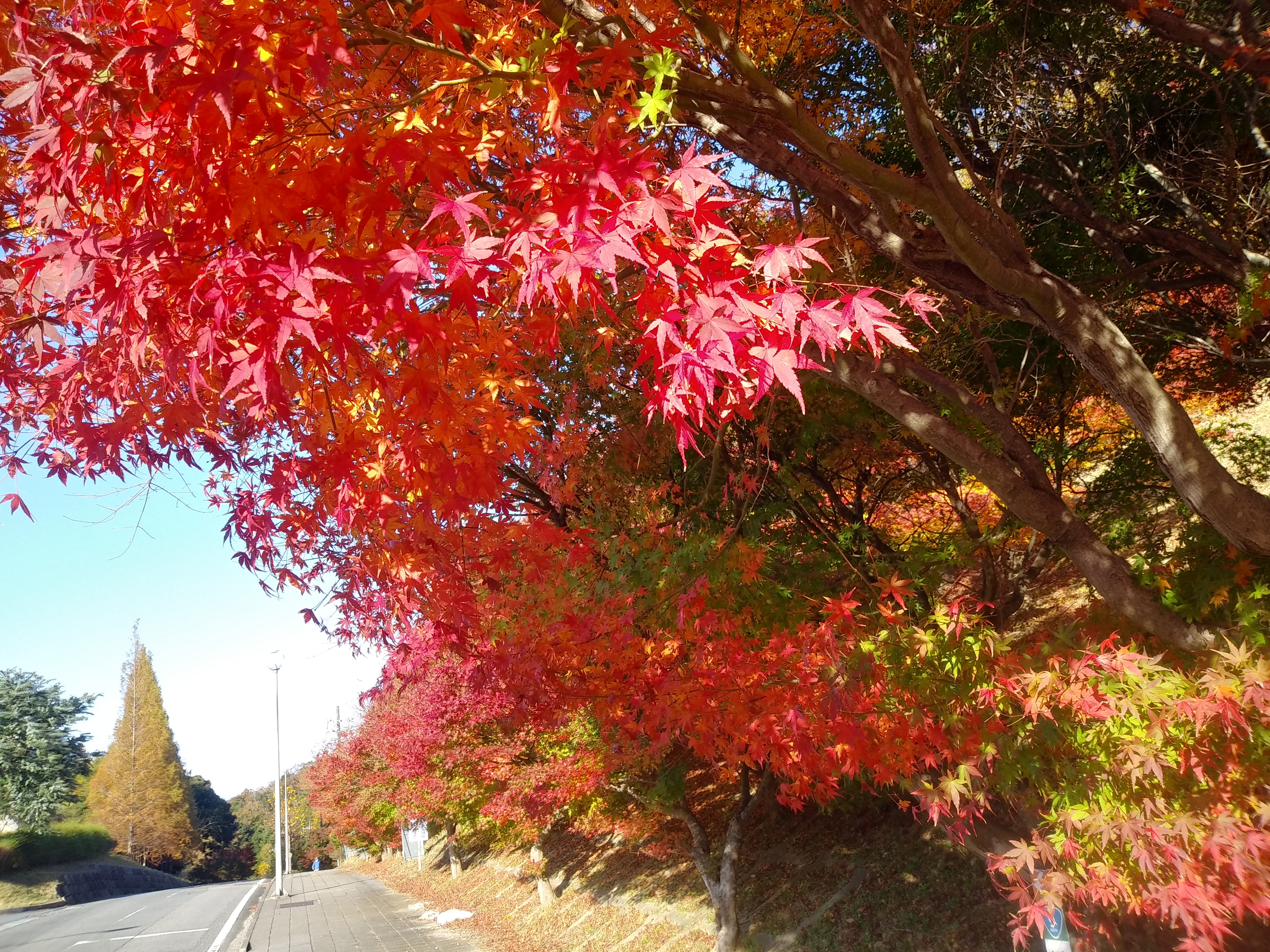
After about a kilometer you will come to a left turn for kendo 県道306 signed for Kanagi and Nagayasuhongo. Take that road and climb back up and over the pass, then descend enjoying the view. After about 2km from the top of the pass you’ll come to a junction with a road to the left and a bridge. The way straight on starts to climb. Take the road left and continue the gentle descent (if you miss the turn - there are no signs - its OK, but the climb up is a hint, just take the next major left (kendo 県道52 signed to Kanagi) once you’ve descended into the main part of Yasaka). In cherry blossom time this descent has plenty of pretty blossoms to see.
In another kilometer or so you arrive at a T junction with a school in front of you. Turn left onto kendo 県道52 and after another 100m or so turn left again onto kendo 県道179, signed Onagami Dam. If you didn’t have lunch at the curry place and want udon instead then instead of turning left continue straight on around another couple of bends and you see the entrance drive to the udon place on the right. Also the vending machines on the corner of the 52/179 junction will be the last vending machines for another 20km or so. You may want to take the opportunity to refill your drink bottle.
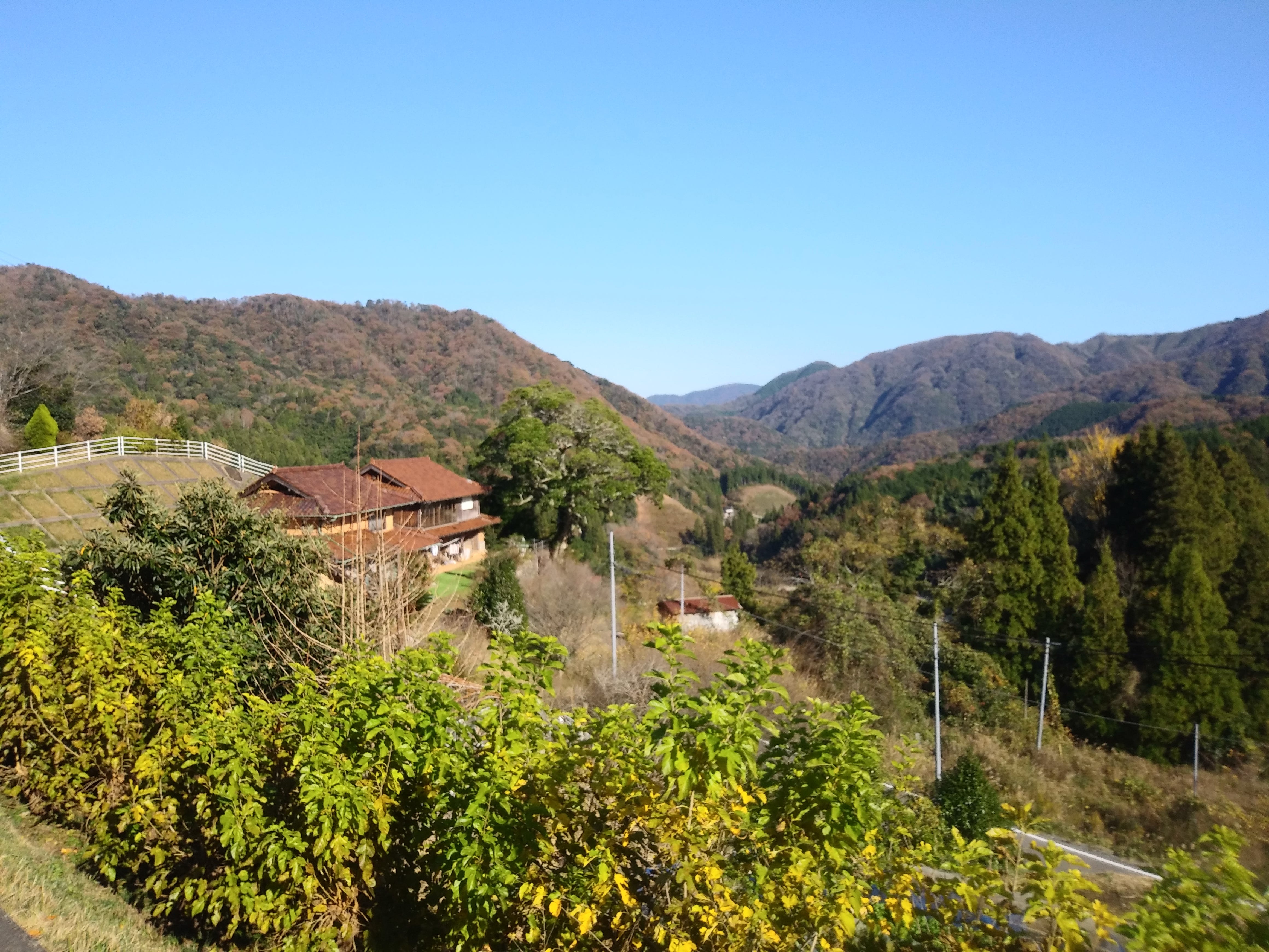
Route 179 starts with a gentle ascent to a pass follwed by a windy and steeper descent to the lake behind the Onagami dam. It’s a moderately busy road so take care and expect to meet at least one susprised vehicle coming up the hill as you descend. As the road flattens out at the bottom you’ll pass a public toilet with all mod cons including toilet paper and electric lighting on the left. Quite why it is there is a mystery known only to the politicians who approved that bit of pork spending but it is there and may be worth taking advantage of. Just past the toilet you reach the bridge across the lake (koyoko 紅葉湖). This is a good view spot as is the observatory on the other side of the bridge. Stop and take a selfie or two.

Then continue up the hill until you see the road to the left signed Onagami Dam (again). Take that road and descend back to the dam. The dam is also pretty scenic and if you want to collect “Dam Cards” the bloke in the visitor center will give you one if you ask him. (There are 4 dams near by that will give you cards: this one, the Hamada #2 dam, the Onbe dam and the Kitsuka dam and you could easily collect three on a ride like this by taking the alternative route via kendos 48 and 179 to the Onbe dam and then crossing over the bridge in the middle of the lake and turning left. This brings you up to kendo 34 below the Kitsuka dam)
Once you’ve done enough looking around at the dam continue down the road. The gorge is quite pretty in various spots - though the more photogenic are after the little Nagami dam (no card available). There’s a pretty waterfall the comes in on the other side of the river about 1 km further on and some pretty pools with nice reflections of the banks. After a bit you cross over the river and then after a few more winds you get to a T junction where you tunr right to continue along the river for another hundred meters or so. Then you get to a T junction with kendo 34 whre you turn left and start climbing.
[Alternative - turn right and continue to ride down the river valley until you get to Sufu. Then join route 9 and continue following sigs to Masuda until you get to Misumi and signs to the start. I don’t really recommend this as even with the highway route 9 can be pretty busy, but it is flatter and you do get some good views of the coast, particularly around Orii and the Yuhi Park Misumi Michi no Eki ]
After less than 1 Km climbing you’ll see a road to the right - kendo 303 signed to Ino - .which you should take. Then after another few hundred meters kendo 303 tunrs off to the left and there’s another road (a nodo) going straight across the river. Kendo 303 is extremely poky so don’t take it (unless you really want to ride up a narrow road with rocks and leaves on the surface). Instead stay in the valley for a bit more then at a point where the nodo has a rise to a junction with a narrow road to the right take that road and contour around the valley gradually climbing. There’s a spot where you need to do a single zig-zag back and forth which gives you a nice view back down the valley you’ve climbed.
The climb gets steeper as you pass the new bridge where the valley nodo joins from the left but that climb only lasts for about another 500m and then you see kendo 303 come in from the left and you are at the top of the pass. Congratulations. It’s basically downhill all the way from here as you now have no more major ascent on the route until you get back to the final climb up to the start.
The road wiggles along a shoulder and down the other side for a bit before widening out and straightening out. The views are spectacular. After a while you will see kendo 303 go off to the right again as you remain on kendo 304 and continue down the river valley. A couple of km further on there’s a turn to the left to stay in the river valley while kendo 304 starts to climb up again. This turn is not signed, but if you miss the turn you’ll quickly realize it because the kendo narrows and starts climbing.
Stay on the wide road for another kilometer or so and then turn left to cross over the bridge and join the road you cycled up earlier. Unless you want to do a loop, turn right and return back to the start the way you came. As an alternative just before you get to the long tunnel you can turn left and contine down the river valley. This is worth doing in the spring during cherry blossom time there’s a spectacular cherry tree a few km down the valley.
Relive link (in English - so you can see the route in 3d)
Navitime link (in Japanese - so you can see the map and potentially download it)