


Red Horses and a Dragon's Head in Ohnancho (邑南町)
(not to mention fine dining ...)


Ohnan Town is not precisely the middle of nowhere, but it’s certainly tending in that direction - being large and sparsely populated with just under 10,000 inhabitants spread across over 400 km² in the mountainous middle of the Chugoku region. Still it borders Hiroshima prefecture and part of it is an hour drive from the middle of Hiroshima city so at weekends it’s gets a fair number of visitors from Hiroshima. But there are places there that even these Japanese, almost local, visitors don’t seem to know about.
I’m probably going to so a more general Ohnan post because there’s quite a lot to see and do in Ohnan but today I’m just going to mention the north east corner - the hamlets of Yairoshi (八色石) and Fuse (布施)
Red Horse (Akaba) Falls - 赤馬滝
First there’s a lovely waterfall in Fuse called Akaba Falls. I’m not quite clear on the reason for the name, but I suspect it has something to do with the color of the rocks in the river bed which are (guess what?) red. It looks like, from the information sign, that this was an area where there was iron ore mined - probably related to those aforementioned red rocks - and turned into iron via the tatara process.

Access from the main Prefectural Rt 55 is mostly signed - the signs are all in Japanese and say 赤馬滝 but clear none the less. If you are coming up from the Gonokawa then the first sign is at the crossroads just after you cross over a bridge having come down the hill that is the border with Misatocho. Turn left, as the sign says, go past the post office, turn left, then (following the signs) right and left. Then stay on the road alongside the river until you get to a sign board and (tight) parking space. Park here.

If you are coming from other parts of Ohnancho take the small road that forks off to the right just as the buildings start. That puts you on the same road that people coming from the Gonokawa are on after they passed the post office and turned left.

Once you have parked your car (or bike) take a look at the large overgrown cliff behind the information board and note the jutting out rock that could be a Tengu’s beak

Then head downstream a short distance to the red foot bridge and sign, and cross over the river and start heading up the smaller river to the falls.
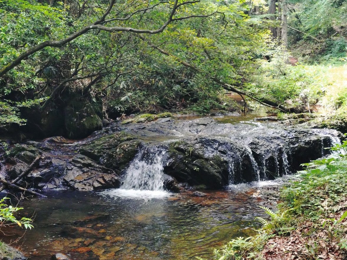
There are a number of pools and small cascades on the way and the first time we visited (sweaty August some years ago) there were children paddling in the pools and parents who were clearly thinking of joining them.
There’s also a path off to the right to go to the top of the falls. We have never taken it, if we do on a later trip and it is worthwhile I’ll update this. The main path ends up at a spot where it splits.
There’s a bridge across the river to a view spot with gazebo on the left, a path to the base of the falls straight on and an overgrown set of irregular stone steps up to a little jizo.
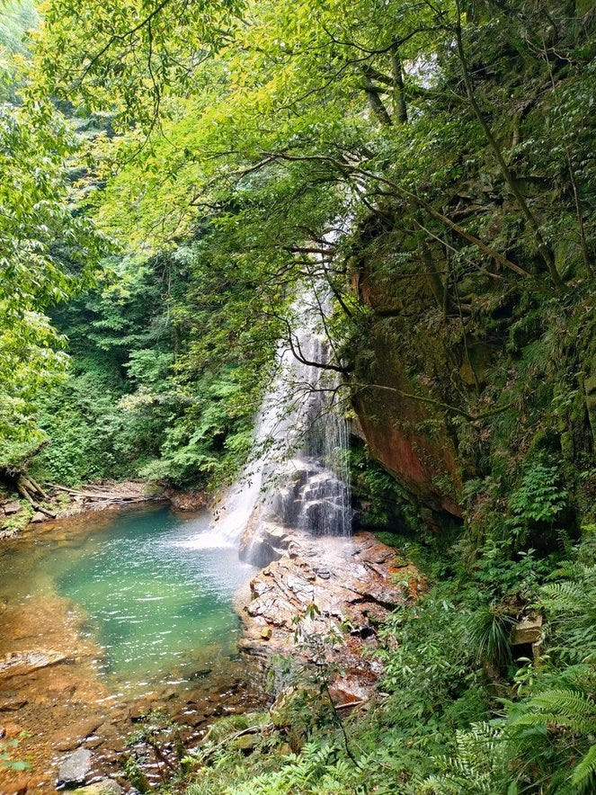
It’s worth climbing up the steps because you can then turn left and go a few steps to the left and get a great view of the falls and pool (above).

It’s also worth going past the gazebo on rocky non-paths to where you can see the falls direct.
The water fall is not as spectacularly large as the Joseitaki which we visited a month ago, but it’s big enough, cool and easier to get to from the road. It’s not the only water fall around but be aware that the road that goes down from these falls to the nearby Banryukyo is narrow, with rocks and branches on the road (see this streetview from 2023). If you do want to visit the Bantyukyo too (and if you have time it’s worth it) it is better to go back to pref rt 55. go over the hill and then follow the signs on the other side.
Yairoshi and the Dragon
The Japanese characters for Yairoshi (八色石) literally mean Eight Color Stone. Since Yairoshi is just a short distance upstream from Fuse and the Akaba falls, almost certainly the reason for the name is partly from more multicolored ores in the hillsides.
However there’s a myth that the name is because of an eight colored rock that was sometimes a dragon and sometimes a kami and which once it was killed split into two with the head turning to stone and ending up on top a hill there1. This myth is, allegedly, how Iwami province got its name. I can’t find a good English translation of the myth (you can try putting this page through your translation program of choice) but google did a more or less adequate job of translating what was posted on an information sign that I took a picture of

It’s a fun story that has echoes of the Susanoo vs Orochi tale that allegedly took place on the banks of the Hiikawa river just a few dozen miles away in Unnan/Oku-izumo. I like it partly because the hero kami who kills the rock/dragon is Yatsukamizuomizunu (八束水多臣津野命) who is also the kami of the Kunibiki myth and partly because it’s the story told in an Iwami Kagura2 performance that I really like - Iwagami (石神3 -Youtube video ).

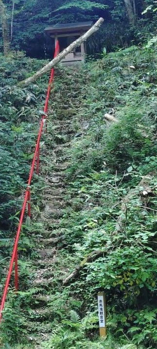
The place where the head landed is now a shrine called the Tatsuiwa Shrine (龍岩神社) and if you visit it you can see the head. I posted a teaser note about the shrine that shows the way up which has a lot of steps (434 according to my count).

The shrine itself is quite simple but there’s some nice carving on the lintel that seems to be older than the rest of the building and around the back there’s the dragon’s head rock…

The picture doesn’t really do it justice because live you can make out what could be a mouth and eyes.
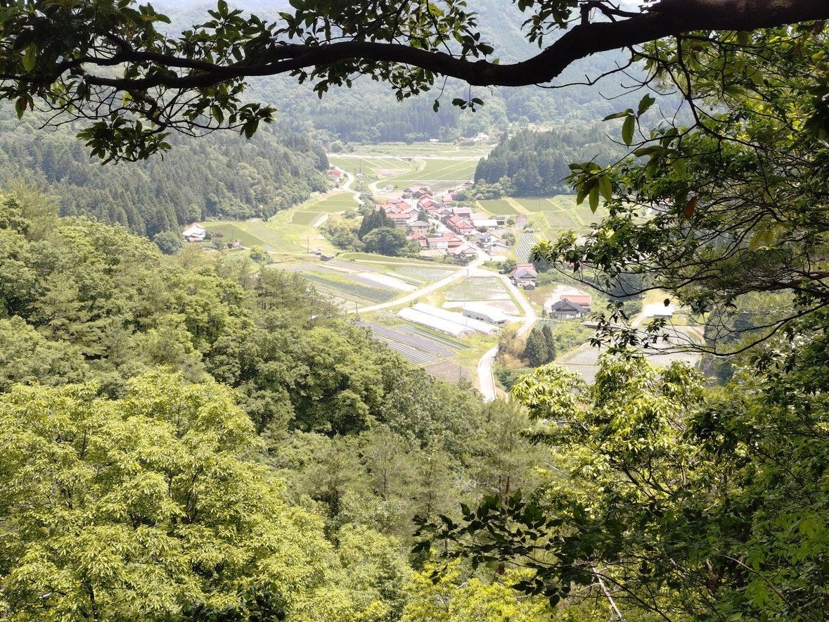
You also get a magnificent view down to the village and across to other mountains.
Fine Dining
All this climbing up steps and paths to visit dragons heads and water falls can work up an appetite. Fortunately Ohnan has quite a few restaurants that can help you out here.

The closest one is called Ochirato which will give you very nice French inspired cuisine from a chef who trained in (IIRC) Lyon and was then chef at restaurant in Tokyo before deciding to go for an easier life in the countryside. The restaurant is in a old building (kominka) some three miles south of Yairoshi (google map link). You get soup, salad and some kind of main dish for about JPY1500. Previously coffee was included but now that’s a JPY100 addition.


Most of the ingredients are local and at this time of year you can see some of next year’s rice growing in the tanbo next to it. You should probably call for a reservation in advance though because there are only four or five tables and, especially at weekends, it can get quite a few customers.
Bon Appetit!
PS A Note About Roads
Just because google (or your maps app of choice) tells you that there’s a road that does not mean you ought to drive it. Many marked roads are narrow and some are extremely overgrown and/or have rocks and branches that you may need to stop and kick to the side rather than drive over. Encountering other vehicles on these roads is generally rare, but can be a major pain because there may be no easy way to pass short of one of you reversing around a few sharp corners with exciting drops into rivers that may be lacking guardrails.
I strongly recommend using google street view to see what the road looked like when the google vehicle last drove it, and to check the date when that happened. In this part of Shimane it looks like most of the roads were driven in the summer of 2023 so not much is likely to have changed but if you find one dated earlier then that probably means the 2023 survey vehicle couldn’t make it. If the road has no street view at all that’s a major warning sign that you don’t want to go there! If you ask, say, google to give you directions do check to see where the app tells you to go and make sure it isn’t guiding you down some poky little track.
Specifically, as I mentioned above, I do not recommend driving down the road between the Akaba falls and the Banryukyo. I also do not recommend taking prefectural route 31 from Yairoshi to Kawamoto, even though that’s the road where the title picture for this article was taken. The 2.5km from the tunnel to the junction with pref rt 296 is fairly narrow and very windy and has enough traffic that you are relatively likely to meet a vehicle coming the other way. Figuring out who reverses and to where so you can pass is NOT fun.
The tail ended up some 50km away between Mito and Hikimi in Masuda
Iwami Kagura - 石見神楽

Note: This post is too long for email, so please view it in the app or a browser.
Readers who know Japanese kanji will note that 石神 is usually pronounced Ishigami not Iwagami and that Iwagami would normally be written 岩神. In this case we have an irregular reading.
Very enjoyable read!
Alas my fluency in nihongo is pretty much limited to Sumimasen, bīru kudasai! ;-)